TYPHOONS
In 2011, 40 tropical depressions entered the Philippine Area of Responsibility (PAR), 21 of these became storm. Tthe first typhoon felt in the month of April while the last, which was the most damaging, was in December. The month of July has the most number of typhoons with 6; followed by (five) 5 typhoons in September. Typhoon Sendong in December was the most devastated claiming hundreds of lives in the southern part of the Philippines.
Eight (8) typhoons hit the Cordillera region; the first typhoon May was the last typhoon was in the first week of October. The most damaging typhoons were Mina, Pedring and Quiel but the first casualties reported due to typhoon was in in July 25, 2011 during typhoon Juaning wherein 4 individuals died in Aguinaldo, Ifugao due to rain-induced landslides.
Typhoon Mina hit the region with continuous rain for three days from August 25 to 27, 2011; this resulted to distinctive damages because the retaining wall of the dumpsite in Irisan, Baguio City collapsed. The trash slide incident claimed 6 lives, injured 9 persons and damaged several houses. It also contaminated 10 water sources of communities near the area from the leach that overflowed from the Irisan dumpsite. Typhoon Mina placed Baguio and Benguet Province under state of calamity.
Death toll for Typhoon Mina casualty was 15; 6 in trash slide, 17 injured, 3 missing and 312 families (7,051 individuals) evacuated due to flooding threats, landslides and ground subsidence. It also ruined 257 million pesos worth of crops and infrastructures, 23 houses totally damaged and 319 partially damaged. 51 roads closed due to road cuts including 2 major landslides along the Halsema Highway wherein two vehicles were swept to the precipice in their attempt to cross the road cut.
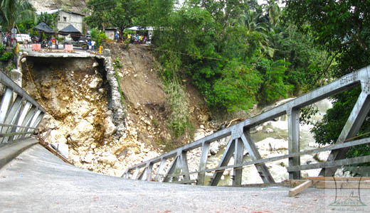
Typhoon Pedring (Nesat) and Quiel (Nalgea) hit the region on September 25- 27, 2011 and September 30 – October 1, 2011 respectively. The two typhoons put most of the provinces in the region under Tropical Storm Signal # 3. All classes at all levels and government offices were suspended; communications bogged down in Kalinga, Ifugao, Mt. Province, Abra and in some areas of Benguet. Apayao and Ifugao sustained heavy damages; in fact, Ifugao was isolated for almost a month due to damaged bridges and roads. Damages valued at 243 million pesos worth of agricultural products and infrastructures in the entire region.
Four (4) died in Ifugao including 3 children due to fallen tree and landslide, 24 injured and 2 were missing. Report showed that 163 houses were partially damaged and 2 were totally damaged. In Abra 12 schools were partially damaged. The strong winds and rain resulted in flooding in low-lying areas of Benguet and Lowland Tabuk. Vegetables, strawberries and palay have been submerged thus harvest were reduced significantly.
Typhoons Pedring and Quiel wash out 29 hectares of rice lands along the Chico River in Lowland Tabuk, Kalinga while 9 hectares were left with sand and gravel making it difficult to cultivate. It surpasses the yearly record of three hectares of agricultural land that go with the current of the river. Because of silt deposit, waters of the Chico River find new courses during heavy rains causing flooding of rice lands along its base. Siltation of the Chico River worsened due to uncontrolled illegal cutting of trees in Upper Kalinga in exchange for swift cash from the sale of lumbers.
RAIN INDUCE LANDSLIDES
The Cordillera region is among the top 10 landslide prone areas in the Philippines. The provinces of Benguet and Mountain Provinces assumed the first and second slots respectively based on new study of the Department of Environment and Natural Resources (DENR). This situation is attributed to the natural characteristics of the region wherein 90% of its total land area of 1,821,691.98 hectares is characterized by steep to very steep slope. The mountainous nature is contributory to the region’s vulnerability to rain-induced landslides.
In Baguio City, 26 Barangays were declared as susceptible to landslide due to unstable grounds. Ground instabilities is a form of creeping, a type of mass and downward movement of slope materials like rocks and soil. Most of the areas are critical and recommended for mitigation measures, furthermore construction of houses and other infrastructures were banned. Recently, DENR-MGB recommended for relocation of a school and houses in Barangay Balangao in Natonin, Mt. Province for being in hazardous location. It was found out that most of the underlying materials within the said place are thick debris or slide deposit that could have came from the mountain above the area caused by landslide years ago. Sinking usually occurs during heavy rains when water slowly carries loose and unconsolidated soil causing tilting and partial destruction of the structures.
Rain-induced landslides in the region are widespread. Earth movements happen during heavy rains, the longer rain will hit the region, and the more landslides occur as the soil gets soaked heavy and are loosed during rainy days.
Human initiated landslide was due to the reduction of forest cover, at present only 36 % forest cover remains. Moreover, the remaining forest cover are mostly second growth trees because the region was covered by many big logging concessions in the past years. The large-scale mining activities also contributed to mountains stripped of forest cover buy cutting trees and open pit mining activities.
The slash and burn” agricultural system the upland communities in Kalinga, Mountain Province, Abra, and Benguet is still persistent which in away contribute to forest degradation. In the vegetable producing areas, expansion towards the forest and watershed areas also add to slimming forest cover and reduction of water supply. Small-scale logging is still prevalent in the remaining forest areas for housing and furniture needs. These malpractices are adding burden to the worsening environment but can not be preventable because the people need to survive.
Millions worth of damages were recorded yearly, significant percentage from the government funds are allocated to respond during emergencies and to repair damages. This year only, 119 million pesos was allocated for the restoration of 2 giant road cuts along the Halsema highway which was caused by typhoon Pepeng in 2009 and aggravated by recent typhoons.
DEVELOPMENT AGRESSIONS
Hydro Projects
The region serves as source water for irrigation systems in Northern Luzon. It is also a source of water for 5 large hydro electric power plants and smaller hydro power plants. The two of the three existing mega hydro projects in Benguet were rehabilitated and operational this year under the management of SN Aboitez Power Corporation. These 3 dams pose flooding in the lowland provinces during rainy season when the dams’ capacity exceeded and need to release waters. This year, there was no incident of flooding due to water release from the reservoirs.
However, SN Aboitez Corporation management pioneered the registration of the two newly rehabilitated dams to the Clean Development Mechanism (CDM) a project of the United Nations Framework on Climate Change (UNFCC). CDM is a mechanism under the Kyoto Protocol to the UNFCC allowing industrialized countries committed to greenhouse gas reduction to invest in climate friendly ventures in developing countries. It allows emission- reduction projects in developing countries to earn carbon emission reduction (CER) credits. This endeavor is indeed good; however, industrialized countries are using the resources of developing countries to earn CER credits for them to freely emit greenhouse gases.
Several hydro projects that were long planned are being revived, this year the feasibility study of the Siffu Dam project in Eastern Mountain Province was completed without any knowledge of the affected communities except for selected government officials who gave their consent. In Tabuk, Kalinga a 20 MW Hydro project caused misunderstandings of the different communities because the host tribe gave its consent without involving the other affected communities. In Sabangan, Mountain Province, two mini dams are due for implementation but community members are raising issues on water rights, residents claimed that the dams pose submersion most of their rice fields that are located along the head water of the Chico River.
Large Scale Mining
With the government’s thrust to increase foreign investment in the Philippines, many foreign large scale mining corporations are keep on flocking in the Cordillera Region to venture in large scale mining. That is why large mining corporations apply 70 % of the total land area of the region for mining activities. The encroachment of ancestral lands of the indigenous peoples by large mining corporations were rampant, the proper process of obtaining permit to operate or explore was not followed. Affected individuals, tribal groups and local government units are against large-scale mining due to the bad experiences and destruction to the environment by existing mining companies in the region.
Significant mining issues for the year included the failure of the Royalco Mining Company in Gambang, Bakun to obtain the Free Prior Inform Consent (FPIC) from the host community. The FPIC is the principle that a community has the right to give or withhold its consent to proposed projects that may affect the lands they customarily own, occupy or otherwise use. It is a pre-requisite for development projects in areas occupied by indigenous peoples or communities as provided for under the Indigenous Peoples Rights Act. Some local government units joined in protesting the anomalous way the mining corporation was able to obtain its permit to operate.
In Mountain Province and Kalinga where most of the new mining applications are concentrated, the provincial government units passed resolutions to express their opposition to the mining activities in their provinces. Particular in Sadanga, one tribal group opposed the pre-operation activities of Malibato Mining Corporation. In Lacub, Abra, the local government facilitated for the entry of several mining companies in the municipality to the extent of harassing government employees who are against large scale mining. The presence of military men in contested areas of mining operations is very significant wherein many human right violations happened on the part of the civilians.
The three existing large-scale mining operations in Benguet have expanded and intensified their mechanized mining activities. This caused massive lay off and shortened working hours of the mineworkers. The use of machines and chemicals also worsened the situation of the environment. Many of the mined areas are landslides prone and sinking areas due to disturbed foundation of the soil by mining activities.
DOST found traces of mercury in four rivers in Kalinga, this contamination poses hazard to the water itself and on living things as the bodies of water will continue to accumulate the element and settle in the riverbeds. This will pose hazard to health to the people utilizing the river for domestic and irrigation uses. They attributed that the source of mercury in the Pasil river were remnants of the Batong Buhay mining operation that closed in the late 1980s and from new mining explorations within the Municipality of Pasil wherein their were new explorations being done by several mining companies. Authorities are also connecting the presence of mercury in Saltan and Cal-oan Rivers due to a small scale mining activities in the municipality of Balbalan wherein they are using chemicals and improved tools.
DENGUE EPIDEMIC
49 barangays in the Cordillera Region was affected by dengue with reported cases of 2,151 individuals mostly children. As of the month of September 2011, death toll rose to 13 with Kalinga has the most number of deaths with 5 victims. In the municipality of Paracelis in Mountain Province, though there was no death recorded, the place was under the state of calamity due to high number of dengue patients in September 2011 with 490 individuals affected.
The alarming epidemic of dengue may be attributed to some factors such as unplanned urbanization, existence of problems in relation to disposal of waste and delayed response to epidemics.
POVERTY
The worsening poverty situation in the region puts the people more vulnerable to disasters. Abra and Apayao are in the list of the top 10 poorest provinces in the Philippines. 34.08% or 79,816 households are poor based from latest study conducted by the Department of Social Welfare and Development (DSWD).
Due to poverty, urban migration is uncontrollable; people from the provinces are moving towards the urban areas in search for jobs or better living condition. In the City of Baguio, urbanization is one of its major problems, from its more than 5,500 hectares land area, only 500 hectares have remaining trees due to continuing building of houses despite restrictions imposed by the government. People from the rural areas struggle for their daily survival to the extent of sacrificing the natural resources such as destruction of the forest due to kaingin, expansion of agricultural lands towards the watershed or forest areas, carabao logging and engaging in small scale mining activities.
The never ending disasters happening in the region brought significant loses yearly. The responses on the damages keep on consuming huge amount from the budget of the government. Hence, fund for poverty alleviation programs can not be increase and poverty response programs are inadequate.